


Jasper is the largest national park in the Canadian Rockies, almost the size of the state of Connecticut. It is 265 km (227 miles) southwest of Edmonton and 288 km (179 miles) northwest of Banff. The park was established in 1907 as Canada's fifth national park. The park covers 11,228 square km (4335 sq mi), one of the world's largest protected mountain ecosystems. Jasper is part of the UNESCO Canadian Rocky Mountain Parks World Heritage site, one of 15 World heritage sites in Canada.
The Yellowhead Highway, part of the 2859 km (1777mi) Trans-Canada Highway 16, runs east-west across Canada.


The 366 km (227 mi) section running southwest from Edmonton to Jasper includes views of the Jasper Lake sand dunes, the only sand dunes in the Canadian Rockies. Jasper Lake is actually part of the Athabasca River.


The 14 km (8.6 mi) Cavell Road leads from the Astoria River Bridge 26.4 km (16.4 mi) southwest of Jasper townsite to the Astoria Valley viewpoint, Mount Edith Cavell and the Angel Glacier, 28 km south of Jasper, and Cavell Meadows.


Mount Edith Cavell and Angel Glacier, stretching between the north face of Mount Edith Cavell and Sorrow Peak. Mount Edith Cavell is the highest mountain in the Jasper area, 3363 m (11.033'). The trail overlooks Cavell Pond, which is fed by the Cavell Glacier.


Cavell Meadows is carpeted with wildflowers from mid-July to mid-August.


Lichens


Old Fort Point Loop Trail. Old Fort Point is a bedrock knob sculpted by glaciers.


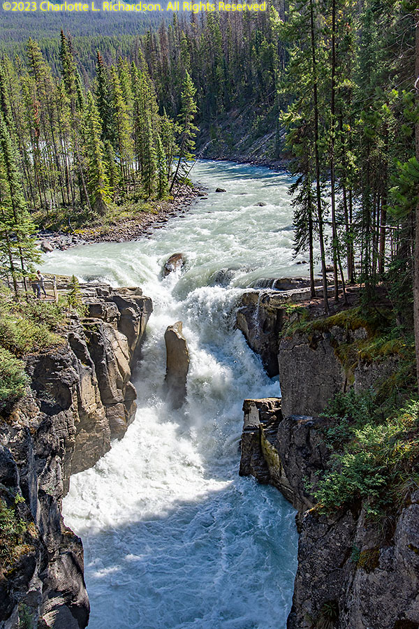
The Maligne Valley includes the Athabasca Valley lookout, Maligne Canyon, Medecine Lake, and Maligne Lake:
Maligne Canyon, 50m (165') deep, has six bridges over the Maligne River. The canyon is limestone, with a waterfall at its head. It is the deepest canyon in Jasper. The best views are from the first and second bridges. The tallest waterfall is near the second bridge, and there is a spectacular waterfall near the third bridge.


Maligne Lake Road, 47 km (29 mi) along the glacial valley between the Maligne and Elizabeth mountain ranges.


Medecine Lake, about 20m (12 miles) southeast of Jasper, is about 7m (4.3 miles) long. It is not actually a lake but an area where the Maligne River, flowing from Maligne Lake into the Athabasca River, backs up and suddenly disappears underground as a losing stream (drains into the aquifer). During meltwater time in the summer, the lake fills. It has a population of rainbow and brook trout, and supports extensive wildlife.


Maligne Lake is the second-largest glacier-fed lake in the world, 22 km (14 mi) long. It is the largest natural lake in the Canadian Rockies. The indigenous peoples called it Chaba Imne, meaning "Beaver Lake".

The very-scenic Icefields Parkway, highway 93, connects Jasper townsite 230 km (143 mi) to Lake Louise in Banff National Park. Highlights within Jasper include Athabasca Falls, Sunwapta Falls, the Columbia Icefield, and Sunwapta Pass.


Athabasca Falls, 23 m (75') is not the highest waterfall in the Canadian Rockies but it is the most powerful; the Athabasca River carries more water than any other river in the Rocky Mountains.


Sunwapta Falls, upper and lower falls. Sunwapta is the Stoney word for "turbulent river". The upper falls has a drop of 18.5 m (60').


The Columbia Icefield covers an area of about 325 sq km (125 square miles) among the tallest mountains at the southern end of Jasper National Park, one of the largest icefields south of the Arctic Circle and the largest south of Alaska. It is the hydrographic apex of North America, with water flowing into three different oceans from one point. The edge of the icefield is visible from the highway.

Stutfield Glacier stretches down 914 m (3000') of cliff face forming a set of double icefalls visible from a roadside viewpoint 95 km (57 mi) south of Jasper.

The 7-km-long Athabasca Glacier is one of eight major glaciers making up the Columbia Icefield. The Athabasca is the most-visted glacier in North America.


Tangle Falls is a 48m (157') multi-tiered, 4 drops, waterfall right off the Icefields Parkway.


Sunwapta Pass marks the boundary between Jasper and Banff National Parks about 108 km (67 mi) southeast of Jasper. It is the second-highest point on the Icefields Parkway, the low point of the saddle between Mount Athabasca and Nigel Peak at 6677'.
Jasper wildlife:
Rocky Mountain mule deer, Odocoileus hemionus hemionus


Rocky Mountain goat, Oreamnos americanus

Elk (wapiti), Cervus canadensis


North American brown (grizzly) bear, Ursus arctos horribilis


American black bear, Ursus americanus


American pika, Ochotona princeps


American red squirrel, Tamiasciurus hudsonicus

Bald eagle, Haliaeetus leucocephalus


Common raven Corvus corax

Pine siskin, Carduelis pinus

California gull, Larus californicus


Canada goose, Branta canadensis

©2023 Mermaid Underwater Photographic. All Rights Reserved.
Contact us at mermaid@underwater.org.
Last modified 21 August 2023